
Topic 3A - Introduction To Monitoring The Land
The Copernicus Sentinel satellites provide us with a wealth of data that can be used for monitoring Earth’s land.
Sentinel-1 is a two-satellite constellation. Each satellite carries an advanced radar instrument that provides an all-weather, day-and-night supply of imagery of the Earth’s surface.
Sentinel-2 comprises of a constellation of two polar-orbiting satellites placed in the same sun-synchronous orbit, phased at 180° to each other. Its purpose is to monitor variability in land surface conditions, and its wide swath width (290 km) and high revisit time - it supports monitoring of Earth’s surface changes.
Sentinel-3’s main objective is to measure sea surface topography, sea and land surface temperature, and ocean and land surface colour with high accuracy and reliability to support ocean forecasting systems, environmental monitoring and climate monitoring.
The Copernicus Land Monitoring Service is divided into four main sections:
- The systematic monitoring of biophysical parameters produces mainly a series of qualified bio-geophysical products on the status and evolution of the land surface. This is produced at a global scale every ten days with a mid spatial resolution and is complemented by a long term time series. The products are used to monitor vegetation, crops, water cycle, energy budget and terrestrial cryosphere variables.
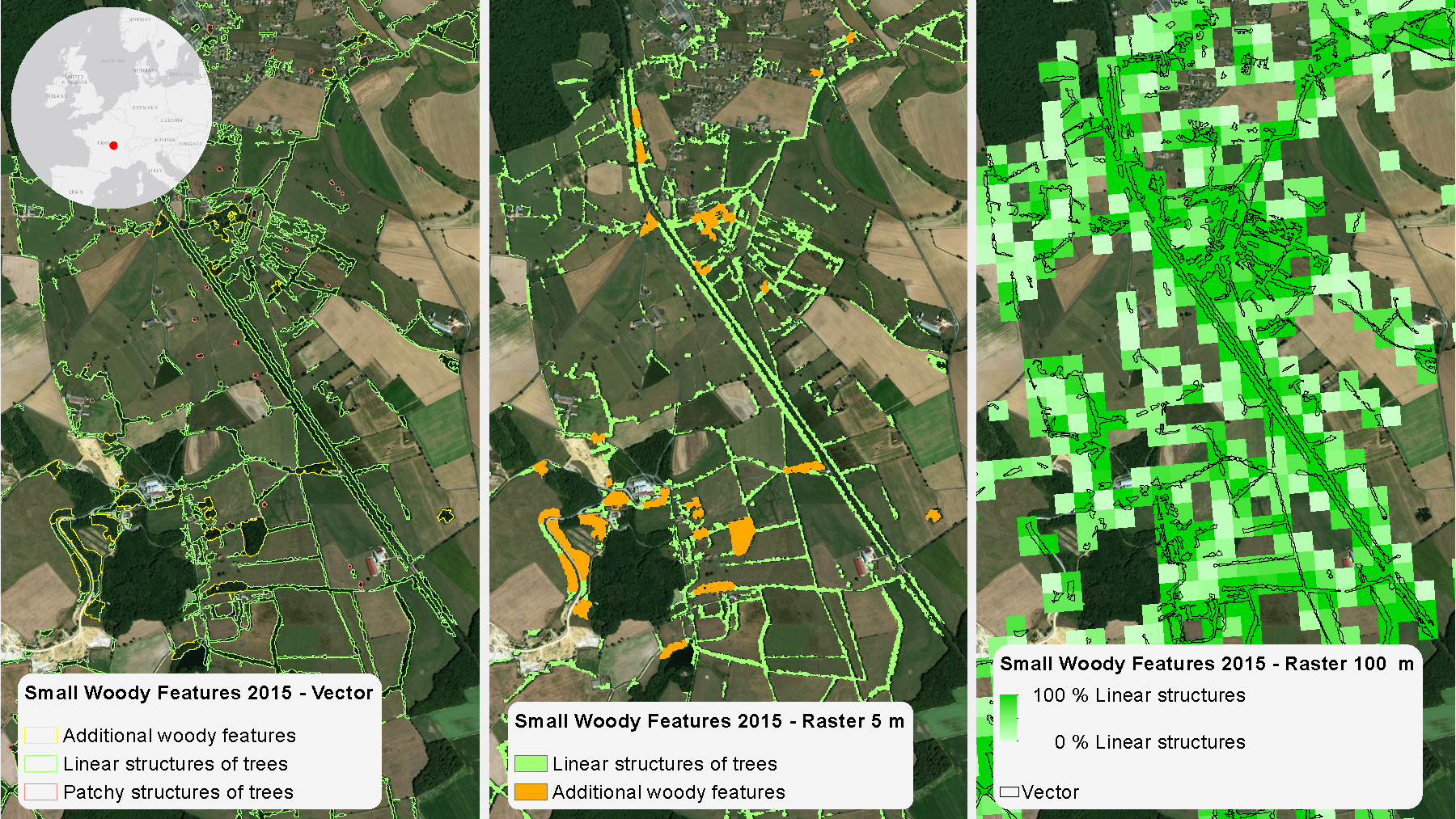
- Land cover and land use mapping produces land cover classifications at various levels of detail, both within a pan-European and global context. At the pan-European level, these are complemented by detailed layers on land cover characteristics, such as imperviousness, forests, grassland, water and wetness and small woody features. At global level, a reference for the land cover mapping is represented by the FAO’s modular-hierarchical Land Cover Classification System.
- Thematic hot-spot mapping aims to provide tailored and more detailed information on specific areas of interest, known as hot-spots. Hotspots in the context of CLMS are prone to specific environmental challenges.
- Imagery and reference data provide satellite image mosaic in high and very high resolutions and reference datasets. This includes, on the one hand, satellite image mosaic from contributing missions covering the territory of Europe as well as Sentinel-2 image mosaic production at global level. On the other hand, it consists of reference datasets providing homogeneous pan-European coverage of some key geospatial themes, such as hydrography and elevation.
CLMS is jointly implemented by the European Environment Agency and the European Commission DG Joint Research Centre (JRC) and has been operational since 2012.
Featured Educator
- Hans Dufourmon
©
©


