
Topic 2f - Urban Development - Part 2 - Further Examples of EO’s Role in Local Policy and Accountability
In this video we hear more examples of how the ESA supported initiatives are enabling a wide range of applications in urban development contexts, and EO’s role in supporting local policy and accountability.
Featured Educators
- Thomas Abell, Asian Development Bank
- Ellen Hamilton, World Bank
- Ede Ijjasz-Vasquez, (Formerly World Bank)
- Anna Wellenstein, World Bank
No items found.
MOOC topics
In this MOOC, each topic is introduced through a video with supporting text.
We have also provided a range of optional further reading, links, and additional resources to help consolidate your learning. Here is a summary of what is available:
Topic links and resources
In each topic, once you have watched the video and read the accompanying text, you will find the following information:
- Optional Further Reading: These are external links to further reading and other resources.
- Featured Images and Featured Animations: Below the text on Topic video page, you will find the featured images and featured animations that were shown in the Topic video.
- Interactives: On the 'Interactives' tab on relevent topic pages, you will find some interactive data viewers (e.g. ESA's Climate from Space tool), allowing you to explore a selection of data relevant to the themes and topics in this MOOC.
Quizzes
- Quizzes: At the end of each Chapter (and in the middle of Chapter 2) there will be a quiz consisting of around five questions. These will help you consolidate your understanding of new topics, but are not scored. The feedback given with answers will also provide you with important information. These quizzes are informal and therefore there is no formal scoring.
Certificate
- Participation certificates are available for this MOOC, you can request one using the form at the end of the course.
Thank you! Your submission has been received!
Oops! Something went wrong while submitting the form.
Optional Further Reading
Featured Images and Example Data

Amman, Jordan
NASA’s Landsat 5 satellite captured this natural-color image of Amman, Jordan, on December 3, 2010. The city forms a rough V shape of gray. West of the city, the terrain is more rugged, with small valleys extending toward the Jordan River.
©
NASA Earth Observatory image created by Jesse Allen, using Landsat data provided by the United States Geological Survey
Source Link
Mecca, Saudi Arabia
ESA astronaut Thomas Pesquet snapped this image of the city of Mecca in Saudi Arabia during his second long-duration mission known as Alpha.
©
ESA/NASA–T. Pesquet
Source Link
Middle Eastern terrain
The south-eastern parts of Iran (top) and the Arabian Peninsula are featured in this image, acquired by Envisat’s Medium Resolution Imaging Spectrometer on 4 February 2011.
©
ESA
Source Link
Middle East Heatwave
This map shows air temperatures in the Middle East and Eastern Mediterranean on June 6, 2021. The map was derived from the Goddard Earth Observing System (GEOS) model and depicts air temperatures at 2 meters (about 6.5 feet) above the ground. The darkest red areas are where the model shows temperatures around 50°C (122°F).
©
NASA Earth Observatory image
Source Link
Urban green spaces in Amsterdam
Urban green spaces in Amsterdam segmented with 10m resolution Sentinel-2 images
©
Pleiades/CNES
Source Link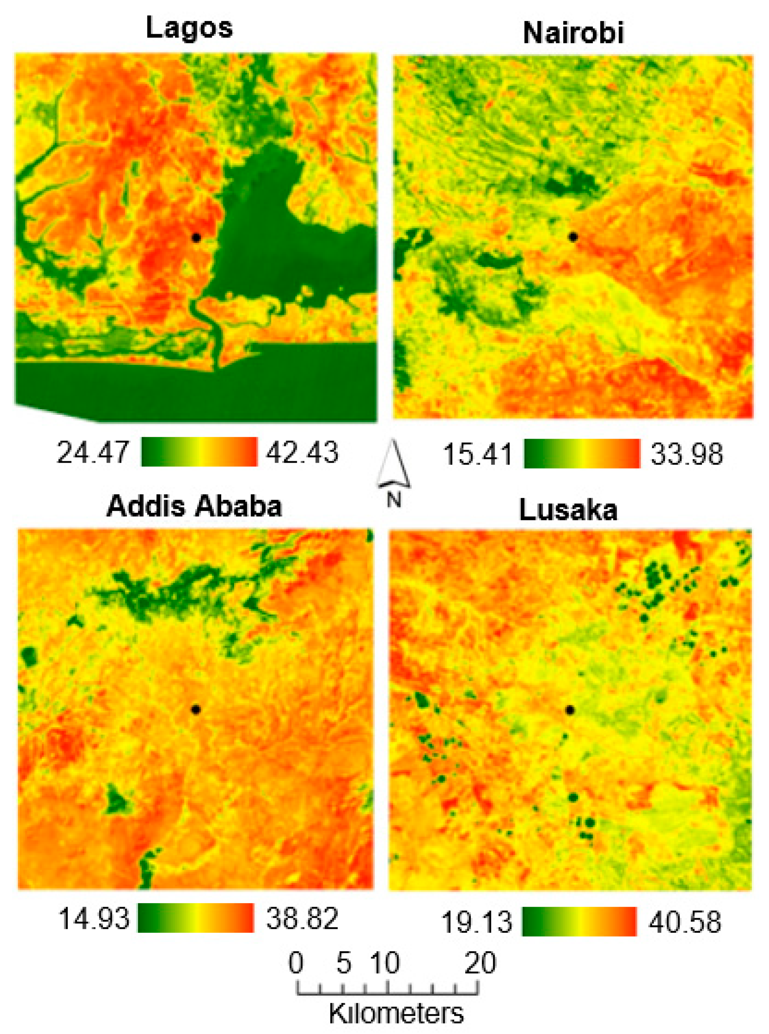
Land surface temperature, Africa
Land surface temperature (LST) distribution in Lagos, Nairobi, Addis Ababa and Lusaka
©
Simwanda, M., et al., 2019
Source Link
Jeddah’s seaport, Saudi Arabia
This image was acquired on 17 March 2013 by the Korea Aerospace Research Institute’s Kompsat-2 satellite
©
KARI/ESA
Source Link
The Gulf
This image, was captured by Sentinel-3A on 30 September 2018 over the Gulf
©
contains modified Copernicus Sentinel data (2018), processed by ESA
Source Link
Antofagasta, Chile
Antofagasta, a port city in northern Chile, is featured in this image captured by the Copernicus Sentinel-2 mission
©
contains modified Copernicus Sentinel data (2021), processed by ESA
Source Link
Lima, Peru
Lima, the capital and largest city of Peru, is featured in this Copernicus Sentinel-2 image captured on 20 April 2020
©
contains modified Copernicus Sentinel data (2020), processed by ESA
Source Link
New Cairo, Egypt
Ladsat image of Cairo and New Cairo, Egypt, taken on September 5, 2019. New Cairo is a 'satellite city' conceived in the early 1990s to help relieve congestion in Cairo
©
NASA Earth Observatory
Source Link
Nairobi, Kenya
This image from Sentinel-2 takes us over Nairobi on 3 February 2019, one of the fastest growing cities in East Africa
©
contains modified Copernicus Sentinel data (2019), processed by ESA
Source Link
Jakarta, Indonesia
Jakarta, Indonesia taken on September 11, 2019
©
NASA Earth Observatory images by Lauren Dauphin, using Landsat data from the U.S. Geological Survey
Source Link
Manila Bay and Laguna de Bay
Luzon in the Philippines, with part of the city of Manila in the upper left. This image was captured by the Copernicus Sentinel-2A satellite on 8 May 2016.
©
Contains modified Copernicus Sentinel data (2016), processed by ESA
Source Link
Kuala Lumpur, Malaysia
Kuala Lumpur, the capital city of Malaysia, is featured in this image captured by the Copernicus Sentinel-2 mission.
©
contains modified Copernicus Sentinel data (2020), processed by ESA
Source Link
Desert irrigation
ESA’s Proba-V minisatellite gives a false-colour view of circular fields fed by underground water resource in the midst of the desert.
©
ESA/Belspo – produced by VITO
Source Link
Desert fields, Saudi Arabia
This image from Sentinel-2A shows how Saudi Arabia’s desert is being used for agriculture. The circles come from a central-pivot irrigation system, where the long water pipe rotates around a well at the centre.
©
Copernicus Sentinel data (2015)/ESA
Source Link
Ulaanbaatar, Mongolia
The Advanced Land Imager (ALI) on NASA’s Earth Observing-1 (EO-1) satellite acquired this true-color image on July 24, 2009 of Ulaanbaatar, Mongolia
©
NASA
Source Link
Adis Abeba, Ethiopia
The Advanced Spaceborne Thermal Emission and Relfection Radiometer (ASTER) on NASA’s Terra satellite captured this image of Adis Abeba on December 16, 2007. In this false-color image, red indicates vegetation, blue-black indicates water, beige indicates bare ground, and blue-gray indicates buildings and/or paved surfaces.
©
NASA
Source Link
Riyadh at Night
Astronaut photograph acquired on November 13, 2012 of the city of Riyadh, the capital city of Saudi Arabia
©
NASA
Source Link
Middle East
This Moderate Resolution Imaging Spectroradiometer (MODIS) image from the Terra satellite shows the Mediterranean Sea (left) and portions of the Middle East. Countries pictured are (clockwise from top right) Syria, Iran, Saudi Arabia, Egypt (across the Gulf of Aqaba), Israel, the disputed West Bank Territory, and Lebanon. In the center is Jordan.
©
MODIS Rapid Response Team, NASA/GSFC
Source LinkFeatured Videos and Animations

Downtown Dubai
This image acquired on 4 January 2012 by the Pleiades satellite shows part of Dubai in the United Arab Emirates.
©
CNES 2012/Astrium Services/Spot Image
Source LinkDownload Resources
No items found.
Discussion
